QuickPUNCH data guide#
A notebook guide to working with QuickPUNCH data in Python
[1]:
# Load libraries

import matplotlib.pyplot as plt
import numpy as np

from astropy.io import fits
from astropy.wcs import WCS
from astropy.io.fits import header

import astropy.units as u

from sunpy.map import Map

from ndcube import NDCube
[2]:
# Specify data filepath

wfi_qp_filename = './data/PUNCH_L2_WQM_20230704000000.fits'
nfi_qp_filename = './data/PUNCH_L2_NQN_20230704000000.fits'
[3]:
# Open the HDU list, and read out the appropriate data
# As the data is RICE compressed, the *second* HDU contains the main data frame
# The third HDU contains a corresponding uncertainty array

with fits.open(wfi_qp_filename) as hdul:
    print('WFI QuickPUNCH HDU List:')
    hdul.info()
    wfi_qp_data = hdul[1].data
    wfi_qp_header = hdul[1].header
    wfi_qp_uncertainty = hdul[2].data

with fits.open(nfi_qp_filename) as hdul:
    print('NFI QuickPUNCH HDU List:')
    hdul.info()
    nfi_qp_data = hdul[1].data
    nfi_qp_header = hdul[1].header
    nfi_qp_uncertainty = hdul[2].data
WFI QuickPUNCH HDU List:
Filename: ./data/PUNCH_L2_WQM_20230704000000.fits
No.    Name      Ver    Type      Cards   Dimensions   Format
  0  PRIMARY       1 PrimaryHDU       4   ()
  1  COMPRESSED_IMAGE    1 CompImageHDU    156   (1024, 1024)   float32
  2  COMPRESSED_IMAGE    1 CompImageHDU      9   (1024, 1024)   uint8
NFI QuickPUNCH HDU List:
Filename: ./data/PUNCH_L2_NQN_20230704000000.fits
No.    Name      Ver    Type      Cards   Dimensions   Format
  0  PRIMARY       1 PrimaryHDU       4   ()
  1  COMPRESSED_IMAGE    1 CompImageHDU    157   (1024, 1024)   float32
  2  COMPRESSED_IMAGE    1 CompImageHDU      9   (1024, 1024)   uint8
[4]:
# The primary data arrays are stored as standard ndarrays
# The uncertainty data array has the dimensions as the primary data array
# Both the primary and uncertainty data arrays share the same header, contained in the primary HDU

print('WFI data array size:', wfi_qp_data.shape)
print('WFI uncertainty array size:', wfi_qp_uncertainty.shape)
WFI data array size: (1024, 1024)
WFI uncertainty array size: (1024, 1024)
[5]:
# The corresponding headers can be queried as AstroPy header objects

wfi_qp_header['DATE-OBS']
[5]:
'2023-07-04T00:00:00.00'
[6]:
# The header information can be converted into an AstroPy WCS object

wfi_qp_data_wcs = WCS(wfi_qp_header);
nfi_qp_data_wcs = WCS(nfi_qp_header);
WARNING: FITSFixedWarning: CROTA = 0.0 / Rotation with respect to reference angle
keyword looks very much like CROTAn but isn't. [astropy.wcs.wcs]
WARNING: FITSFixedWarning: CROTA_A = 0.0 / Rotation with respect to reference angle
keyword looks very much like CROTAn but isn't. [astropy.wcs.wcs]
WARNING: FITSFixedWarning: 'datfix' made the change 'Set MJD-OBS to 60129.000000 from DATE-OBS.
Set MJD-BEG to 60129.000000 from DATE-BEG.
Set MJD-AVG to 60129.002778 from DATE-AVG.
Set MJD-END to 60129.005556 from DATE-END'. [astropy.wcs.wcs]
[7]:
# Construct a SunPy Map object of out this data

wfi_qp_data_map = Map(wfi_qp_data, wfi_qp_header)
nfi_qp_data_map = Map(nfi_qp_data, nfi_qp_header)
[8]:
# Display this SunPY Map object

wfi_qp_data_map
WARNING: SunpyMetadataWarning: Could not parse unit string "Mean Solar Brightness" as a valid FITS unit.
See https://docs.sunpy.org/en/stable/code_ref/map.html#fixing-map-metadata for how to fix metadata before loading it with sunpy.map.Map.
See https://fits.gsfc.nasa.gov/fits_standard.html forthe FITS unit standards. [sunpy.map.mapbase]
[8]:
<sunpy.map.mapbase.GenericMap object at 0x7fc0097818e0>
|
Image colormap uses histogram equalization
Click on the image to toggle between units 
|
||||||||||||||||||||||||

|
[9]:
# Display this SunPY Map object

nfi_qp_data_map
WARNING: SunpyMetadataWarning: Could not parse unit string "Mean Solar Brightness" as a valid FITS unit.
See https://docs.sunpy.org/en/stable/code_ref/map.html#fixing-map-metadata for how to fix metadata before loading it with sunpy.map.Map.
See https://fits.gsfc.nasa.gov/fits_standard.html forthe FITS unit standards. [sunpy.map.mapbase]
[9]:
<sunpy.map.mapbase.GenericMap object at 0x7fc009781730>
|
Image colormap uses histogram equalization
Click on the image to toggle between units 
|
||||||||||||||||||||||||

|
[10]:
# Construct an NDCube object out of this data

wfi_qp_data_ndcube = NDCube(wfi_qp_data, wcs=wfi_qp_data_wcs)
nfi_qp_data_ndcube = NDCube(nfi_qp_data, wcs=nfi_qp_data_wcs)
[11]:
# Take a quick look at these NDCube objects

wfi_qp_data_ndcube, nfi_qp_data_ndcube
[11]:
(<ndcube.ndcube.NDCube object at 0x7fbfe96fe3a0>
 NDCube
 ------
 Dimensions: [1024. 1024.] pix
 Physical Types of Axes: [('custom:pos.helioprojective.lon', 'custom:pos.helioprojective.lat'), ('custom:pos.helioprojective.lon', 'custom:pos.helioprojective.lat')]
 Unit: None
 Data Type: float32,
 <ndcube.ndcube.NDCube object at 0x7fbfd92aee50>
 NDCube
 ------
 Dimensions: [1024. 1024.] pix
 Physical Types of Axes: [('custom:pos.helioprojective.lon', 'custom:pos.helioprojective.lat'), ('custom:pos.helioprojective.lon', 'custom:pos.helioprojective.lat')]
 Unit: None
 Data Type: float32)
[12]:
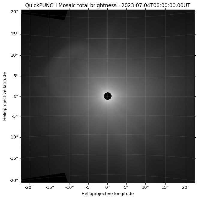
# Display this data in a regular plotting environment, using the associated WCS

plt.figure(figsize=(7.5, 7.5))
ax = plt.subplot(111, projection=wfi_qp_data_wcs)
plt.imshow(np.log(wfi_qp_data), cmap='Greys_r', vmin=-16, vmax=0)
lon, lat = ax.coords
lat.set_ticks(np.arange(-90, 90, 5) * u.degree)
lon.set_ticks(np.arange(-180, 180, 5) * u.degree)
lat.set_major_formatter('dd')
lon.set_major_formatter('dd')
ax.set_facecolor('black')
ax.coords.grid(color='white', alpha=.1)
plt.xlabel("Helioprojective longitude")
plt.ylabel("Helioprojective latitude")
plt.scatter(0, 0, s=240, color='k', transform=ax.get_transform('world'));
plt.title('QuickPUNCH Mosaic total brightness - ' + wfi_qp_header['DATE-OBS'] + 'UT')
/var/folders/py/f06qj9p54jzfxlzpr79z7z0wvsr0ty/T/ipykernel_68963/3721481304.py:5: RuntimeWarning: divide by zero encountered in log
  plt.imshow(np.log(wfi_qp_data), cmap='Greys_r', vmin=-16, vmax=0)
[12]:
Text(0.5, 1.0, 'QuickPUNCH Mosaic total brightness - 2023-07-04T00:00:00.00UT')
[13]:
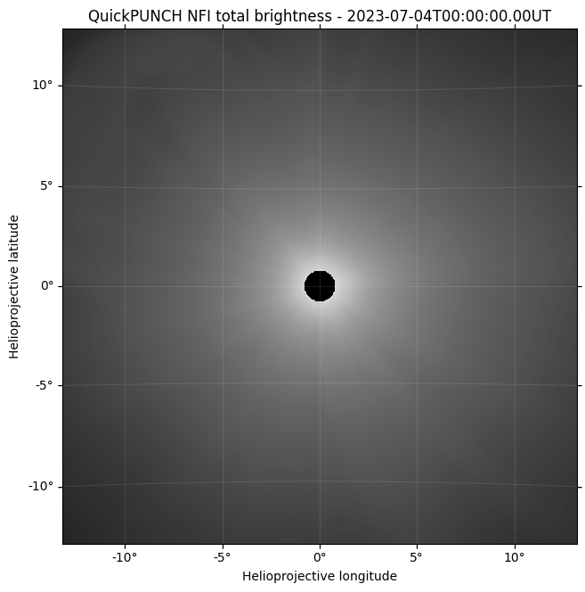
# Display this data in a regular plotting environment, using the associated WCS

plt.figure(figsize=(7.5, 7.5))
ax = plt.subplot(111, projection=nfi_qp_data_wcs)
plt.imshow(np.log(nfi_qp_data), cmap='Greys_r', vmin=-16, vmax=0)
lon, lat = ax.coords
lat.set_ticks(np.arange(-90, 90, 5) * u.degree)
lon.set_ticks(np.arange(-180, 180, 5) * u.degree)
lat.set_major_formatter('dd')
lon.set_major_formatter('dd')
ax.set_facecolor('black')
ax.coords.grid(color='white', alpha=.1)
plt.xlabel("Helioprojective longitude")
plt.ylabel("Helioprojective latitude")
plt.scatter(0, 0, s=240, color='k', transform=ax.get_transform('world'));
plt.title('QuickPUNCH NFI total brightness - ' + nfi_qp_header['DATE-OBS'] + 'UT')
/var/folders/py/f06qj9p54jzfxlzpr79z7z0wvsr0ty/T/ipykernel_68963/2980633537.py:5: RuntimeWarning: divide by zero encountered in log
  plt.imshow(np.log(nfi_qp_data), cmap='Greys_r', vmin=-16, vmax=0)
[13]:
Text(0.5, 1.0, 'QuickPUNCH NFI total brightness - 2023-07-04T00:00:00.00UT')
[14]:
# Again noting that these files are compressed, additional keywords will be visible when viewing these FITS files outside of Python.
# These keywords relate to the compression implementation, and can be retreived using astropy.io.fits, if needed, using the disable_image_compression keyword.

with fits.open(wfi_qp_filename, disable_image_compression=True) as hdul:
    header_compression = hdul[1].header

header_compression
[14]:
XTENSION= 'BINTABLE'           / binary table extension
BITPIX  =                    8 / array data type
NAXIS   =                    2 / number of array dimensions
NAXIS1  =                   32 / width of table in bytes
NAXIS2  =                 1024 / number of rows in table
PCOUNT  =              1602185 / number of group parameters
GCOUNT  =                    1 / number of groups
TFIELDS =                    4 / number of fields in each row
TTYPE1  = 'COMPRESSED_DATA'    / label for field 1
TFORM1  = '1PB(1985)'          / data format of field: variable length array
TTYPE2  = 'GZIP_COMPRESSED_DATA' / label for field 2
TFORM2  = '1PB(0)  '           / data format of field: variable length array
TTYPE3  = 'ZSCALE  '           / label for field 3
TFORM3  = '1D      '           / data format of field: 8-byte DOUBLE
TTYPE4  = 'ZZERO   '           / label for field 4
TFORM4  = '1D      '           / data format of field: 8-byte DOUBLE
ZIMAGE  =                    T / extension contains compressed image
ZSIMPLE =                    T / Conforms to FITS Standard
ZBITPIX =                  -32 / Number of bits per pixel
ZNAXIS  =                    2 / Number of axes
ZNAXIS1 =                 1024 / Length of the first axis
ZNAXIS2 =                 1024 / Length of the second axis
ZTILE1  =                 1024 / size of tiles to be compressed
ZTILE2  =                    1 / size of tiles to be compressed
ZCMPTYPE= 'RICE_1  '           / compression algorithm
ZNAME1  = 'BLOCKSIZE'          / compression block size
ZVAL1   =                   32 / pixels per block
ZNAME2  = 'BYTEPIX '           / bytes per pixel (1, 2, 4, or 8)
ZVAL2   =                    4 / bytes per pixel (1, 2, 4, or 8)
ZNAME3  = 'NOISEBIT'           / floating point quantization level
ZVAL3   =                 16.0 / floating point quantization level
ZQUANTIZ= 'NO_DITHER'          / No dithering during quantization
EXTNAME = 'COMPRESSED_IMAGE'   / name of this binary table extension
COMMENT ----- FITS Required ----------------------------------------------------
LONGSTRN= 'OGIP 1.0'           / The OGIP long string convention may be used

COMMENT ----- Documentation, Contact, and Collection Metadata ------------------
DOI     = 'https://doi.org/TBD'  / Data reference DOI
PROJECT = 'PUNCH'              /
TITLE   = 'PUNCH Level-2 WFI+NFI Mosaic QuickPUNCH Clear Image'
KEYVOCAB= 'Unified Astronomy Thesaurus Keywords'
KEYWORDS= 'Solar Corona (1483), Solar K Corona (2042), Solar F Corona (1991), &'
CONTINUE  'Solar Coronal Streamers (1486), Solar Coronal Plumes (2039), Solar &'
CONTINUE  'Wind (1534), Fast Solar Wind (1872), Slow Solar Wind (1873), Solar &'
CONTINUE  'Coronal Mass Ejection (310), Heliosphere (711), Polarimetry (1278)'
LICENSE = 'Creative Commons Attribution 4.0 International | CC BY 4.0'
COMMENT  PUNCH Level-2 NFI QuickPUNCH Clear data, calibrated for non-linear
COMMENT  photometric correction, deficient pixel removal, data destreaking and
COMMENT  cosmic-ray despiking, vignetting and linear flat-field correction,
COMMENT  stray-light subtraction, PSF correction, star-field alignment, and
COMMENT  data resampling
COMMENT  Rice data compression used
COMMENT  Bad data flagging and quality marking is included in a secondary
COMMENT  uncertainty HDU
COMMENT  Documentation is available on the PUNCH website:
COMMENT  https://punch.spaceops.swri.org and via the DOI referenced above (TBD)

COMMENT ----- File Type and Provenance -----------------------------------------
FILENAME= 'PUNCH_L2_WQM_20230704000000.fits' / Name of file
LEVEL   =                    2 / Product Level
OBSTYPE = 'Unpolarized WFI+NFI Mosaic QuickPUNCH image' / Plain text observation
TYPECODE= 'WQ'                 / Observation product type code
L1PAREN1= 'PUNCH_L1_CL1_20220204134800_v0.fits' / name of parent file
L1PAREN2= 'PUNCH_L1_CL2_20220204134700_v0.fits' / name of parent file
L1PAREN3= 'PUNCH_L1_CL3_20220204134600_v0.fits' / name of parent file
L1PAREN4= 'PUNCH_L1_CL4_20220204135100_v0.fits' / name of parent file
PIPEVRSN= '1.2.3'              / PUNCHPipe software version number
ORIGIN  = 'SwRI'               / Institution responsible for creating the file

COMMENT ----- Temporal Information ---------------------------------------------
TIMESYS = 'UTC'                / Principle time system
DATE-BEG= '2023-07-04T00:00:00.00' / UTC time of observation start
DATE-OBS= '2023-07-04T00:00:00.00' / UTC reference time
DATE-AVG= '2023-07-04T00:04:00.00' / Mean UTC observation time
DATE-END= '2023-07-04T00:08:00.00' / UTC time of observation end
DATE    = '2023-07-04T12:08:00.00' / UTC file generation date and time

COMMENT ----- Instrument and Spacecraft State ----------------------------------
WAVELNTH=                  530 / [nm] Average peak response
WAVEUNIT= 'nanometer'          / Unit of observation measurement
FILTER  = 'Clear'              / Name of filter for observations
OBS-MODE= 'Unpolarized'        / Image Mode (Unpolarized, Polar_M, _Z, or _P)
INSTRUME= 'WFI+NFI MOSAIC'     / Instrument name
TELESCOP= 'PUNCH01-02-03-04'   / Satellite name
OBSRVTRY= 'PUNCH'              / Observatory name
OBJECT  = 'Heliosphere white light' / Object observed

COMMENT ----- World Coordinate System ------------------------------------------
WCSAXES =                    2 / Number of coordinate axes
IMAGEW  =                 1024 / Image width, in pixels
IMAGEH  =                 1024 / Image height, in pixels
WCSNAME = 'Helioprojective Zenithal-Azimuthal Perspective' / Coordinate System
CTYPE1  = 'HPLN-AZP'           / Coordinate type codezenithal/azimuthal perspect
CTYPE2  = 'HPLT-AZP'           / Coordinate type codezenithal/azimuthal perspect
EQUINOX =               2000.0 / Equatorial coordinates definition (yr)
LONPOLE =                180.0 / [deg] Native longitude of celestial pole
LATPOLE =                  0.0 / [deg] Native latitude of celestial pole
CRVAL1  =                  0.0 / [deg] Coordinate value at reference point
CRVAL2  =                  0.0 / [deg] Coordinate value at reference point
CRPIX1  =                511.5 / Pixel coordinate of reference point
CRPIX2  =                511.5 / Pixel coordinate of reference point
CUNIT1  = 'deg'                / Units of coordinate increment and value
CUNIT2  = 'deg'                / Units of coordinate increment and value
CROTA   =                  0.0 / Rotation with respect to reference angle
CDELT1  =                0.045 / [deg] Coordinate increment at reference point
CDELT2  =                0.045 / [deg] Coordinate increment at reference point
PC1_1   =                  1.0 / WCS coordinate description matrix
PC1_2   =                  0.0 / WCS coordinate description matrix
PC2_1   =                  0.0 / WCS coordinate description matrix
PC2_2   =                  1.0 / WCS coordinate description matrix
WCSNAMEA= 'Right Ascension Declination Zenithal-Azimuthal' / Coordinate System
CTYPE1A = 'RA---AZP'           / Right Ascension - Zenithal-Azimuth Perspective
CTYPE2A = 'DEC--AZP'           / Declination - Zenithal-Azimuth Perspective
EQUINOXA=               2000.0 / Equatorial coordinates definition (yr)
LONPOLEA=                180.0 / [deg] Native longitude of the celestial pole
LATPOLEA=                  0.0 / [deg] Native latitude of the celestial pole
CRVAL1A =          249.3460044 / [arcsec] X-coordinate of reference point
CRVAL2A =         -27.25011692 / [arcsec] Y-coordinate of reference point
CRPIX1A =              495.773 / Pixel coordinate of reference point
CRPIX2A =              507.555 / Pixel coordinate of reference point
CUNIT1A = 'deg'                / WCS axis X units (theta_x, right ascension)
CUNIT2A = 'deg'                / WCS axis Y units (theta_y, declination)
CROTA_A =                  0.0 / Rotation with respect to reference angle
CDELT1A =            -0.042305 / [arcsec] Average pixel scale along axis 1
CDELT2A =             0.042305 / [arcsec] Average pixel scale along axis 2
PC1_1A  =         0.9944226355 / WCS coordinate description matrix
PC1_2A  =        -0.0572686183 / WCS coordinate description matrix
PC2_1A  =        0.05721285161 / WCS coordinate description matrix
PC2_2A  =          0.994136111 / WCS coordinate description matrix
PV1_1A  =                  0.0 / [deg] Native longitude of the reference point
PV1_2A  =                 90.0 / [deg] Native latitude of the reference point
PV1_3A  =                180.0 / [deg] Alias for LONPOLE (has precedence)
PV2_0A  =            -1.99E-08 / ZPN projection parameters m=0
PV2_1A  =          1.005010009 / ZPN projection parameters m=1
PV2_2A  =        0.07295829803 / ZPN projection parameters m=2
PV2_3A  =         0.2752920091 / ZPN projection parameters m=3
PV2_4A  =        -0.7018809915 / ZPN projection parameters m=4
PV2_5A  =           1.97518003 / ZPN projection parameters m=5

COMMENT ----- Image Statistics and Properties ----------------------------------
BUNIT   = 'Mean Solar Brightness' / Units of observation [6.4282E7 W/m2/sr]
DATAZER =                    0 / Number of pixels=0
DATASAT =                    1 / Number of saturated pixels
DSATVAL =             1.92E-10 / Saturation value in calibrated units
DATAAVG =             3.89E-11 / Average non-zero pixel value
DATAMDN =             2.82E-11 / Median non-zero pixel value
DATASIG =             3.10E-11 / Standard deviation of non-zero pixels
DATAP01 =             9.90E-13 / 1% of non-zero pixels are LE this value
DATAP10 =             1.43E-11 / 10% of non-zero pixels are LE this value
DATAP25 =             1.89E-11 / 25% of non-zero pixels are LE this value
DATAP50 =             2.82E-11 / 50% of non-zero pixels are LE this value
DATAP75 =             4.73E-11 / 75% of non-zero pixels are LE this value
DATAP90 =             8.01E-11 / 90% of non-zero pixels are LE this value
DATAP95 =             1.08E-10 / 95% of non-zero pixels are LE this value
DATAP98 =             1.40E-10 / 98% of non-zero pixels are LE this value
DATAP99 =             1.59E-10 / 99% of non-zero pixels are LE this value
DATAMIN =                   23 / Minimum valid physical value
DATAMAX =                 1234 / Maximum valid physical value

COMMENT ----- Solar Reference Data ---------------------------------------------
RSUN_ARC=          6276.642451 / [arcsec] Photospheric solar radius
RSUN_REF=            695507968 / [m] Assumed physical solar radius
SOLAR_P0=          0.217279871 / [deg] Angle of geocentric north to solar north
CAR_ROT =                 2272 / Carrington Rotation number

COMMENT ----- Spacecraft Location & Environment --------------------------------
GEOD_LAT=                    0 / [deg] Obs sub-point geodetic latitude
GEOD_LON=                    0 / [deg] Obs sub-point longitude
GEOD_ALT=                    0 / [m] Obs WGS84 altitude
HGLT_OBS=                  0.0 / [deg] Obs heliographic latitude (B0)
HGLN_OBS=                  0.0 / [deg] Obs heliographic longitude
DSUN_OBS=   152091156482.06534 / [m] Obs distance from Sun
CRLT_OBS=                  0.0 / [deg] Obs Carrington latitude
CRLN_OBS=    96.55094869704908 / [deg] Obs Carrington longitude
HEEX_OBS=    694653643.4177302 / [m] Obs Heliocentric Earth Ecliptic X
HEEY_OBS=   -4343692.222176673 / [m] Obs Heliocentric Earth Ecliptic Y
HEEZ_OBS=  -37893772.896766946 / [m] Obs Heliocentric Earth Ecliptic Z

COMMENT ----- FIXITY -----------------------------------------------------------
CHECKSUM= '9hAOGg3O9g9OEg9O'   / HDU checksum updated 2022-03-23T12:35:22
DATASUM = '4040810964'         / Data unit checksum updated 2022-03-23T12:35:22
ZHECKSUM= '9hAOGg3O9g9OEg9O'   / HDU checksum updated 2022-03-23T12:35:22
ZDATASUM= '4040810964'         / Data unit checksum updated 2022-03-23T12:35:22

COMMENT ----- HISTORY ----------------------------------------------------------
HISTORY Records of processing from pipeline
[ ]: